Brighton Antique Prints and Maps
Currency
WOOCS 2.1.5
VIEW CART
  • CURRENCY

    WOOCS 2.1.5
  • Home
  • Catalogue
    • Antique Maps
    • Antique Prints
    • Books & Gov’t Reports
    • Manuscript Documents
  • Recent Arrivals
  • About
  • FAQ
  • Register Interests
  • Contact Us
40-20  Africa – Indiarum Orientalis a Promontorio . . . by de Wit  c.1675

Home/Antique Maps/Africa/Africa - Continent

Antique Map 40-20 Africa – Indiarum Orientalis a Promontorio . . . by de Wit c.1675

SKU: 40-20 Categories: Africa - Continent, Antique Maps, Eastern Africa
3-524  Flinders chart of South Queensland  c.1814
3-820   World by Emanuel Bowen  c.1744
  • Description

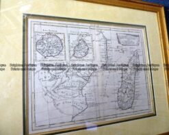
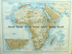
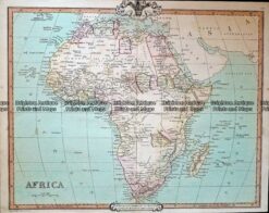
Africa – Indiarum Orientalis a Promontorio by de Wit c.1675
Sea Chart
Copperplate
54cm X 44cm
Condition A+

Expensively framed


These may also be of interest

  • 40-08 - Africa Johnston  - circa 1850 Steel engraving 49cm X 59cm Condition A+
    Africa - Continent

    Antique Map 40-08 – Africa Johnston – circa 1850 Steel engraving 49cm X 59cm Condition A+

    $325.00
  • 40-07 - Africa   Tallis  - circa 1851 Steel engraving 32cm X 24cm Condition A+
    Africa - Continent

    Antique Map 40-07 – Africa Tallis – circa 1851 Steel engraving 32cm X 24cm Condition A+

    $350.00
  • 40-02 - Africa Meissas & Michelot - circa 1859 Hand coloured steel engraving 27cm X 19cm Condition A+
    Africa - Continent

    Antique Map 40-02 – Africa Meissas & Michelot – circa 1859 Hand coloured steel engraving 27cm X 19cm Condition A+

    $190.00
  • Africa - Continent

    Antique Map 230-130 Africae Pars Borealis by Scherer c.1699

    $450.00
© 2026 BRIGHTON ANTIQUE PRINTS AND MAPS. ALL RIGHTS RESERVED | Website by Blaze Online
Credit Card
Norton Safe Web Transaction
  • Home
  • Catalogue
    • Antique Maps
    • Antique Prints
    • Books & Gov’t Reports
    • Manuscript Documents
  • Recent Arrivals
  • About
  • FAQ
  • Register Interests
  • Contact Us
  • View Cart
  • Login
  • Currency
    WOOCS 2.1.5

Sending...