Brighton Antique Prints and Maps
Currency
WOOCS 2.1.5
VIEW CART
  • CURRENCY

    WOOCS 2.1.5
  • Home
  • Catalogue
    • Antique Maps
    • Antique Prints
    • Books & Gov’t Reports
    • Manuscript Documents
  • Recent Arrivals
  • About
  • FAQ
  • Register Interests
  • Contact Us
3-188 World – Typus Orbis Terrarum by Ortelius c.1579

Home/Antique Maps/World/World and Hemispheres

Antique Map 3-188 World – Typus Orbis Terrarum by Ortelius c.1579

SKU: 3-188 Categories: Antique Maps, World and Hemispheres
available_req
3-787 Australia by Bellin French edition
  • Description

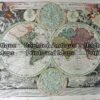
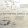
World – Typus Orbis Terrarum by Abraham Ortelius c.1570 (1579)

Hand coloured copperplate engraving
49cm X 34cm
Condition A+

&;


These may also be of interest

  • Antique Maps

    Antique Map 232-575 World – Isothermal Lines by Black c.1862

    $80.00
  • 3-390 World - Distribution of Animals
    Antique Maps

    Antique Map 3-390 World – Distribution of Animals

    $85.00
  • Antique Maps

    Antique Map 233-017 World on Mercator projection by Rand McNally c.1894

    $230.00
  • 16-227 - World - Eastern & Western Hemispheres Pair of maps J Wyld - circa 1840 Hand coloured steel engraving 23cm X23cm Condition A+
    Antique Maps

    Antique Map 16-227 – World – Eastern & Western Hemispheres Pair of maps J Wyld – circa 1840 Hand coloured steel engraving 23cm X23cm Condition A+

    $290.00
© 2025 BRIGHTON ANTIQUE PRINTS AND MAPS. ALL RIGHTS RESERVED | Website by Blaze Online
Credit Card
Norton Safe Web Transaction
  • Home
  • Catalogue
    • Antique Maps
    • Antique Prints
    • Books & Gov’t Reports
    • Manuscript Documents
  • Recent Arrivals
  • About
  • FAQ
  • Register Interests
  • Contact Us
  • View Cart
  • Login
  • Currency
    WOOCS 2.1.5
Brought to you by WisdmLabs: WordPress Development Experts

Sending...