Brighton Antique Prints and Maps
Currency
WOOCS 2.1.5
VIEW CART
  • CURRENCY

    WOOCS 2.1.5
  • Home
  • Catalogue
    • Antique Maps
    • Antique Prints
    • Books & Gov’t Reports
    • Manuscript Documents
  • Recent Arrivals
  • About
  • FAQ
  • Register Interests
  • Contact Us
3-522  Flinders chart of South Australia  c.1814

Home/Antique Maps/Australia & Pacific/WA, SA & NT

Antique Map 3-522 Flinders chart of South Australia c.1814

SKU: 3-522 Categories: Antique Maps, WA, SA & NT
available_req
3-787 Australia by Bellin French edition
  • Description

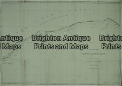
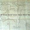
South Australia coast charted by Matthew Flinders &;c.1814
South Coast Sheet III

Copperplate engraving
91cm X 63cm
Condition A


These may also be of interest

  • 11-078 - South Australia - County of Adelaide J Sands - circa 1886 Chromolithograph 42cm X 52cm Condition A+
    Antique Maps

    Antique Map 11-078 – South Australia – County of Adelaide J Sands – circa 1886 Chromolithograph 42cm X 52cm Condition A+

    $225.00
  • 15-100 - Western Australia - Kimberley District A Petermann - circa 1875 Hand coloured steel engraving 39cm X 32cm Condition A+
    Antique Maps

    Antique Map 15-100 – Western Australia – Kimberley District A Petermann – circa 1875 Hand coloured steel engraving 39cm X 32cm Condition A+

    $250.00
  • 15-106 West Australia & Tasmania c.1844
    Antique Maps

    Antique Map 15-106 West Australia & Tasmania c.1844

    $220.00
  • Antique Maps

    Antique Map 230-611 Port Augusta area Military Map c.1942

    $65.00
© 2025 BRIGHTON ANTIQUE PRINTS AND MAPS. ALL RIGHTS RESERVED | Website by Blaze Online
Credit Card
Norton Safe Web Transaction
  • Home
  • Catalogue
    • Antique Maps
    • Antique Prints
    • Books & Gov’t Reports
    • Manuscript Documents
  • Recent Arrivals
  • About
  • FAQ
  • Register Interests
  • Contact Us
  • View Cart
  • Login
  • Currency
    WOOCS 2.1.5
Brought to you by WisdmLabs: WordPress Development Experts

Sending...