Brighton Antique Prints and Maps
Currency
WOOCS 2.1.5
VIEW CART
  • CURRENCY

    WOOCS 2.1.5
  • Home
  • Catalogue
    • Antique Maps
    • Antique Prints
    • Books & Gov’t Reports
    • Manuscript Documents
  • Recent Arrivals
  • About
  • FAQ
  • Register Interests
  • Contact Us
3-793 Australia by Thomson

Home/Antique Maps/Australia & Pacific/Australia - Continent

Antique Map 3-793 Australia by Thomson

SKU: 3-793 Categories: Antique Maps, Australia - Continent
14-226 - Mornington Peninsula Meikle - circa 1854 Colour wash lithograph 50cm X 60cm Condition A+
16-250
  • Description

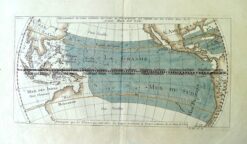
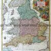
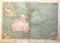
New Holland and Asiatic Isles

Thomson &;circa 1817
Engraving with outline colour
61cm X 49cm
Condition A (very light foxing in parts)
Expensively framed

&;


These may also be of interest

  • Antique Maps

    Antique Map 3-086 – Tasmania J Tallis – circa 1851 26cm X 36cm Condition A+

    $450.00
  • 3-073 - New South Wales J Bartholomew circa 1848 Hand coloured steel engraving 27cm X 38cm Condition A+
    Antique Maps

    Antique Map 3-073 – New South Wales J Bartholomew circa 1848 Hand coloured steel engraving 27cm X 38cm Condition A+

    $190.00
  • 3-898  Australia Geological  c.1886
    Antique Maps

    Antique Map 3-898 Australia Geological c.1886

    $340.00
  • 3-003 - Australia:  Industries & Communications George Philip - circa 1905 Chromolithograph 48cm X 35cm Condition A+
    Antique Maps

    Antique Map 3-003 – Australia: Industries & Communications George Philip – circa 1905 Chromolithograph 48cm X 35cm Condition A+

    $140.00
© 2025 BRIGHTON ANTIQUE PRINTS AND MAPS. ALL RIGHTS RESERVED | Website by Blaze Online
Credit Card
Norton Safe Web Transaction
  • Home
  • Catalogue
    • Antique Maps
    • Antique Prints
    • Books & Gov’t Reports
    • Manuscript Documents
  • Recent Arrivals
  • About
  • FAQ
  • Register Interests
  • Contact Us
  • View Cart
  • Login
  • Currency
    WOOCS 2.1.5
Brought to you by WisdmLabs: WordPress Development Experts

Sending...