CURRENCY
3-811 Geological map of Western Port showing coalfields
Coloured lithograph 54cm X 40cm Condition A+
SOLD
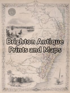
Antique Map 3-862 New South Wales by Tallis circa 1851
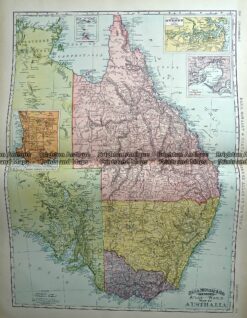
Antique Map 233-225 Australia – Victoria, NSW, Queensland by Rand McNally c.1894
Antique Map 3-070 – New South Wales Picturesque Atlas – circa 1886 Chromolithograph 62cm X 38cm Condition A+
Antique Map 236-037 Australia – railway systems & Telegraph lines c.1942