Brighton Antique Prints and Maps
Currency
WOOCS 2.1.5
VIEW CART
  • CURRENCY

    WOOCS 2.1.5
  • Home
  • Catalogue
    • Antique Maps
    • Antique Prints
    • Books & Gov’t Reports
    • Manuscript Documents
  • Recent Arrivals
  • About
  • FAQ
  • Register Interests
  • Contact Us
3-831 Moorabbin street map  c.1949

Home/Antique Maps/Australia & Pacific/Victoria

Antique Map 3-831 Moorabbin street map c.1949

$160.00

SKU: 3-831 Categories: Antique Maps, Melbourne, Victoria, Victorian Parish & Military Maps
5-138 - Britain - Ethnological Map Johnston - circa 1886 Chromolithograph 33cm X 43cm Condition A
2-113 - Asia - East Indies A Bell - circa 1773 Copperplate 29cm X 18cm Condition A+
  • Description

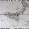
Moorabbin, East Brighton, Bentleigh and part of Sandringham &;c.1949

Lithograph
58cm X 58cm
Condition A


These may also be of interest

  • 14-216 - Victoria - Port Phillip and vicinity John Sands - circa 1886 Chromolithograph 52cm X 42cm Condition A+
    Antique Maps

    Antique Map 14-216 – Victoria – Port Phillip and vicinity John Sands – circa 1886 Chromolithograph 52cm X 42cm Condition A+

    $480.00
  • available_req
    Antique Maps

    Antique Map Wytwallan / Dundas 1880

  • 29-487  Collins and Bourke Street - bird's eye view  c.1906
    Antique Maps

    Antique Print Antique Map 29-487 Collins and Bourke Street – bird’s eye view c.1906

    $65.00
  • Antique Maps

    Antique Print Antique Map 233-234 Gold Mines in Victoria – Ballarat and Bendigo c.1880’s

    $50.00
© 2025 BRIGHTON ANTIQUE PRINTS AND MAPS. ALL RIGHTS RESERVED | Website by Blaze Online
Credit Card
Norton Safe Web Transaction
  • Home
  • Catalogue
    • Antique Maps
    • Antique Prints
    • Books & Gov’t Reports
    • Manuscript Documents
  • Recent Arrivals
  • About
  • FAQ
  • Register Interests
  • Contact Us
  • View Cart
  • Login
  • Currency
    WOOCS 2.1.5
Brought to you by WisdmLabs: WordPress Development Experts

Sending...