Brighton Antique Prints and Maps
Currency
WOOCS 2.1.5
VIEW CART
  • CURRENCY

    WOOCS 2.1.5
  • Home
  • Catalogue
    • Antique Maps
    • Antique Prints
    • Books & Gov’t Reports
    • Manuscript Documents
  • Recent Arrivals
  • About
  • FAQ
  • Register Interests
  • Contact Us
3-899  Australia – Nuova Olanda by Cassini  c.1798

Home/Antique Maps/Australia & Pacific/Australia - Continent

Antique Map 3-899 Australia – Nuova Olanda by Cassini c.1798

SKU: 3-899-2 Categories: Antique Maps, Australia - Continent
3-808 County of Roxburgh by Basch circa 1872
3-791 Cook discoveries in Australia
  • Description

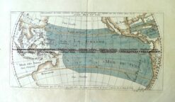
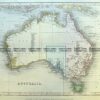
Nuova Olanda e La Nuova Guinea by G Cassini &;c.1798
Third earliest map of Australia to show east coast charted by Cook

Copperplate engraving with original hand colour
49cm X 35cm
Condition A+

SOLD
&;


These may also be of interest

  • 3-218 - Victoria - Counties of Moira
    Antique Maps

    Antique Map 3-218 – Victoria – Counties of Moira, Delatite, Bogong & Wonnangatta John Sands – circa 1886 Chromolithograph 52cm X 42cm Condition A+

    $290.00
  • Australia - Continent

    Antique map – Australia by Wyld c.1872 Ref: 339-031

    $990.00
  • Antique Maps

    Antique Print Antique Map 230-602 Australia and Asia – Indian Ocean shipping routes c.1950

    $175.00
  • 3-064 - New South Wales Picturesque Atlas - circa 1886 Chromolithograph 61cm X 37cm Condition A+
    Antique Maps

    Antique Map 3-064 – New South Wales Picturesque Atlas – circa 1886 Chromolithograph 61cm X 37cm Condition A+

    $125.00
© 2025 BRIGHTON ANTIQUE PRINTS AND MAPS. ALL RIGHTS RESERVED | Website by Blaze Online
Credit Card
Norton Safe Web Transaction
  • Home
  • Catalogue
    • Antique Maps
    • Antique Prints
    • Books & Gov’t Reports
    • Manuscript Documents
  • Recent Arrivals
  • About
  • FAQ
  • Register Interests
  • Contact Us
  • View Cart
  • Login
  • Currency
    WOOCS 2.1.5
Brought to you by WisdmLabs: WordPress Development Experts

Sending...