Brighton Antique Prints and Maps
Currency
WOOCS 2.1.5
VIEW CART
  • CURRENCY

    WOOCS 2.1.5
  • Home
  • Catalogue
    • Antique Maps
    • Antique Prints
    • Books & Gov’t Reports
    • Manuscript Documents
  • Recent Arrivals
  • About
  • FAQ
  • Register Interests
  • Contact Us
4-197  Middlesex England by I. Slater c.1847

Home/Antique Maps/Britain and Ireland/Britain

Antique Map 4-197 Middlesex England by I. Slater c.1846

SKU: 4-197 Categories: Antique Maps, Britain, England
5-060  Asia by Teasdale  c.1844
  • Description

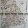
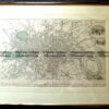
County of Middlesex England by I. Slater c.1846

Hand coloured steel engraving
36cm X 22cm
Condition A+

Other English County maps from the same atlas are available


These may also be of interest

  • City Street Maps

    Antique map – Manchester & Salford Street Map by Verner, Hood & Sharpe c.1805 Ref#232-744

    $130.00
  • 5-166 - England - Isle of Thanet Moule - circa 1840 Hand coloured steel engraving 26cm X 19cm Condition A+
    Antique Maps

    Antique Map 5-166 – England – Isle of Thanet Moule – circa 1840 Hand coloured steel engraving 26cm X 19cm Condition A+

    $240.00
  • 4-194  Cambridgeshire by I. Slater c.1847
    Antique Maps

    Antique Map 4-194 Cambridgeshire by I. Slater c.1846

    $240.00
  • 5-144 - England - Lincolnshire J Dower - circa 1850 Steel engraving 31cm X 43cm Condition A+
    Antique Maps

    Antique Map 5-144 – England – Lincolnshire J Dower – circa 1850 Steel engraving 31cm X 43cm Condition A+

    $150.00
© 2025 BRIGHTON ANTIQUE PRINTS AND MAPS. ALL RIGHTS RESERVED | Website by Blaze Online
Credit Card
Norton Safe Web Transaction
  • Home
  • Catalogue
    • Antique Maps
    • Antique Prints
    • Books & Gov’t Reports
    • Manuscript Documents
  • Recent Arrivals
  • About
  • FAQ
  • Register Interests
  • Contact Us
  • View Cart
  • Login
  • Currency
    WOOCS 2.1.5
Brought to you by WisdmLabs: WordPress Development Experts

Sending...