CURRENCY
Canada – Labrador and Greenland by A Zatta &;c.1778
Hand coloured copperplate engraving 40cm X 30cm Condition A+
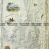
Antique Map 8-193 New Brunswick and Quebec – Canada by Tallis circa 1851
Antique Map 8-182 – Canada J Tallis – circa 1851 Steel engraving 34cm X 25cm Condition A+
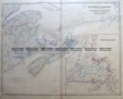
Antique Map 8-198 Canada – Maritime Provinces and Newfoundland by Johnston c.1864
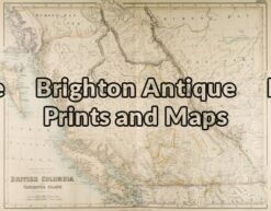
Antique Map 8-185 – Canada – British Columbia J Bartholomew – circa 1854 Steel engraving 54cm X 42cm Condition A+