Brighton Antique Prints and Maps
Currency
WOOCS 2.1.5
VIEW CART
  • CURRENCY

    WOOCS 2.1.5
  • Home
  • Catalogue
    • Antique Maps
    • Antique Prints
    • Books & Gov’t Reports
    • Manuscript Documents
  • Recent Arrivals
  • About
  • FAQ
  • Register Interests
  • Contact Us
8-199  USA- Western States by Johnston  c.1864

Home/Antique Maps/North America/Western USA

Antique Map 8-199 USA- Western States by Johnston c.1864

SKU: 8-199-2 Categories: Antique Maps, Western USA
16-254  Celestial - Star system by Middleton  c.1842
8-807  Michigan (northern) State map  c.1898
  • Description

United States – Western States

Steel engraving
57cm X 44cm
Condition A
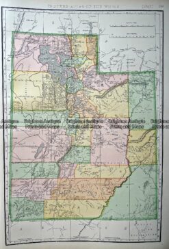

These may also be of interest

  • Antique Maps

    Antique Map 232-003 Inhabitants of California c.1744

    $190.00
  • Antique Maps

    Antique Map 233-252 Wyoming USA by Rand McNally c.1894

    $125.00
  • Antique Maps

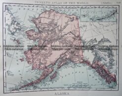
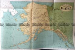
    Antique Map 233-254 Alaska USA by Rand McNally c.1894

    $125.00
  • 8-173 - North America - West Coast J Cook - circa 1779 Copperplate engraving 31cm X 24cm Condition A+
    Antique Maps

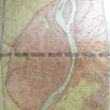
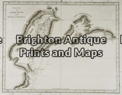
    Antique Map 8-173 – North America – West Coast J Cook – circa 1779 Copperplate engraving 31cm X 24cm Condition A+

    $250.00
© 2025 BRIGHTON ANTIQUE PRINTS AND MAPS. ALL RIGHTS RESERVED | Website by Blaze Online
Credit Card
Norton Safe Web Transaction
  • Home
  • Catalogue
    • Antique Maps
    • Antique Prints
    • Books & Gov’t Reports
    • Manuscript Documents
  • Recent Arrivals
  • About
  • FAQ
  • Register Interests
  • Contact Us
  • View Cart
  • Login
  • Currency
    WOOCS 2.1.5
Brought to you by WisdmLabs: WordPress Development Experts

Sending...