Brighton Antique Prints and Maps
Currency
WOOCS 2.1.5
VIEW CART
  • CURRENCY

    WOOCS 2.1.5
  • Home
  • Catalogue
    • Antique Maps
    • Antique Prints
    • Books & Gov’t Reports
    • Manuscript Documents
  • Recent Arrivals
  • About
  • FAQ
  • Register Interests
  • Contact Us
9-158  Melbourne Street Map – Brighton  c.1920

Home/Antique Maps/Australia & Pacific/Melbourne

Antique Map 9-158 Melbourne Street Map – Brighton c.1920

SKU: 9-158 Categories: Antique Maps, City Street Maps, Melbourne
16-248 -World on Mercators Projection John Tallis - circa 1851 Outline colour steel engraving 32cm X 25cm Condition A+
3-898  Australia Geological  c.1886
  • Description

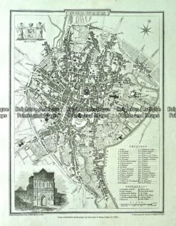
Brighton Street Map &;c.1920

Published by Anderson Gowan
63cm X 100cm
​Condition B

SOLD

A facsimile of the map is available


These may also be of interest

  • 29-491  Carlton
    Antique Maps

    Antique Print Antique Map 29-491 Carlton, Fitzroy and Collingwood c.1906

    $75.00
  • Melbourne

    Antique map – Wonder map of Melbourne c.1934 Ref: 415-002

    $1,500.00
  • City Street Maps

    Antique map – Environs of London by Verner, Hood & Sharpe c.1805 Ref#232-743

    $130.00
  • 5-186 - Spain - Seville street map by Wagner & Dubes c.1911
    Antique Maps

    Antique Map 5-186 – Spain – Seville street map by Wagner & Dubes c.1911

    $95.00
© 2025 BRIGHTON ANTIQUE PRINTS AND MAPS. ALL RIGHTS RESERVED | Website by Blaze Online
Credit Card
Norton Safe Web Transaction
  • Home
  • Catalogue
    • Antique Maps
    • Antique Prints
    • Books & Gov’t Reports
    • Manuscript Documents
  • Recent Arrivals
  • About
  • FAQ
  • Register Interests
  • Contact Us
  • View Cart
  • Login
  • Currency
    WOOCS 2.1.5
Brought to you by WisdmLabs: WordPress Development Experts

Sending...