Brighton Antique Prints and Maps
Currency
WOOCS 2.1.5
VIEW CART
  • CURRENCY

    WOOCS 2.1.5
  • Home
  • Catalogue
    • Antique Maps
    • Antique Prints
    • Books & Gov’t Reports
    • Manuscript Documents
  • Recent Arrivals
  • About
  • FAQ
  • Register Interests
  • Contact Us
500px-image_available_on_request

Home/Antique Maps/Australia & Pacific/Victorian Parish & Military Maps

Antique Map Balloong / Buln Buln 1924

SKU: PMM-18 Categories: Antique Maps, Victorian Parish & Military Maps
available_req
3-524  Flinders chart of South Queensland  c.1814
  • Description

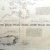
Ninety Mile Beach. Shoal inlet Size: S


These may also be of interest

  • available_req
    Antique Maps

    Antique Map Cut Paw Paw (M) / Bourke 1952

  • Antique Maps

    Antique Map 230-226 Military map of Western Port Vic c.1940

    $125.00
  • available_req
    Antique Maps

    Antique Map Linton / Evelyn

  • available_req
    Antique Maps

    Antique Map Tyabb / Mornington 1959

© 2025 BRIGHTON ANTIQUE PRINTS AND MAPS. ALL RIGHTS RESERVED | Website by Blaze Online
Credit Card
Norton Safe Web Transaction
  • Home
  • Catalogue
    • Antique Maps
    • Antique Prints
    • Books & Gov’t Reports
    • Manuscript Documents
  • Recent Arrivals
  • About
  • FAQ
  • Register Interests
  • Contact Us
  • View Cart
  • Login
  • Currency
    WOOCS 2.1.5

Sending...

Enquiry for Antique Map Balloong / Buln Buln 1924
Brought to you by WisdmLabs: WordPress Development Experts