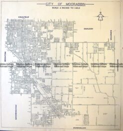
Brighton Antique Prints and Maps
Currency
WOOCS 2.1.5
VIEW CART
  • CURRENCY

    WOOCS 2.1.5
  • Home
  • Catalogue
    • Antique Maps
    • Antique Prints
    • Books & Gov’t Reports
    • Manuscript Documents
  • Recent Arrivals
  • About
  • FAQ
  • Register Interests
  • Contact Us
500px-image_available_on_request

Home/Antique Maps/Australia & Pacific/Victorian Parish & Military Maps

Tallarook – Tallarook, Seymour, Broadford, Yea, Goulburn River (folded)

SKU: PMM-113 Category: Victorian Parish & Military Maps
available_req
available_req

    These may also be of interest

    • available_req
      Antique Maps

      Antique Map Phillip Island (M) / Mornington 1956

    • available_req
      Antique Maps

      Antique Map Yallock / Mornington 1944

    • available_req
      Antique Maps

      Antique Map Boorolite / Wonnangatta 1926

    • available_req
      Antique Maps

      Antique Map Foster – Foster, Toora, Fishcreek, Dumbalk

    © 2025 BRIGHTON ANTIQUE PRINTS AND MAPS. ALL RIGHTS RESERVED | Website by Blaze Online
    Credit Card
    Norton Safe Web Transaction
    • Home
    • Catalogue
      • Antique Maps
      • Antique Prints
      • Books & Gov’t Reports
      • Manuscript Documents
    • Recent Arrivals
    • About
    • FAQ
    • Register Interests
    • Contact Us
    • View Cart
    • Login
    • Currency
      WOOCS 2.1.5
    Brought to you by WisdmLabs: WordPress Development Experts

    Sending...