Skip to content
Brighton Antique Prints and MapsBrighton Antique Prints and Maps
  • CURRENCY

    WOOCS 2.1.5
  • VIEW CART
  • Catalogue
  • Home
  • Catalogue
    • Antique Maps
    • Antique Prints
    • Books & Gov’t Reports
    • Manuscript Documents
  • Recent Arrivals
  • About
  • FAQ
  • Register Interests
  • Contact Us
Antique map - Selwyn geological maps of Melbourne c.1860's.  Ref: 888-179
Home / Antique Maps / Australia & Pacific / Victorian Geological Maps
  • 3-811 Victoria- Western Port by Govt. Printer circa 1872

Antique map – Selwyn geological maps of Melbourne c.1860’s. Ref: 888-179

  • 3-811 Victoria- Western Port by Govt. Printer circa 1872

$1,500.00

Categories: Victorian Geological Maps, Melbourne
  • 3-811 Victoria- Western Port by Govt. Printer circa 1872
Product Categories
  • Antique Maps
    • World
    • Australia & Pacific
      • Australia - Continent
      • Victoria
      • Victorian Parish & Military Maps
      • Victorian Geological Maps
      • Melbourne
      • NSW
      • Tasmania
      • Queensland
      • WA, SA & NT
      • New Zealand
      • Pacific
    • Britain and Ireland
    • Europe
    • Asia
    • North America
    • South America
    • Africa
    • City Street Maps
    • Geological maps
    • Tallis
  • Antique Prints
  • Books & Gov't Reports
  • Manuscript Documents
  • Description
  • Reviews (0)

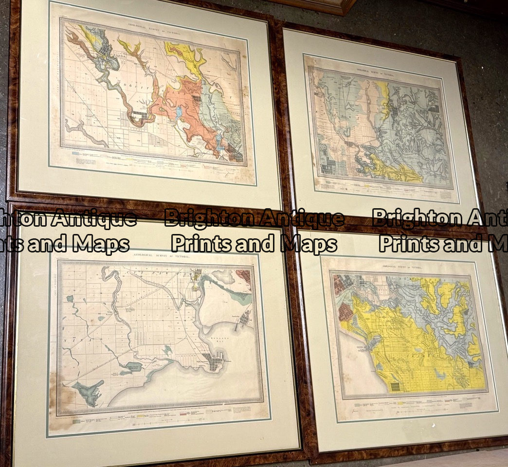
Geological Maps of Melbourne in four parts by Alfred Selwyn.
Probably earliest comprehensive geological survey.

Background: Shortly after the discovery of gold in Victoria, Governor LaTrobe urged the Colonial Office in London to appoint a Mineral Surveyor. Alfred Selwyn was appointed in May 1852 and shortly after his arrival in Melbourne he commenced the Geological Survey of Victoria. By the 1860’s his maps were regarded among the best geological maps in the world.

To find the set of four Melbourne maps is exceptional. The maps measure approximately 48cm X 40cm plus wide margins. Conservatively framed.

Price . . . $1,500 for set of four maps. Postage within Australia is estimated at $100, if sent in frames. Much less postage if sent unframed or without glass.

Reviews

There are no reviews yet.

Be the first to review “Antique map – Selwyn geological maps of Melbourne c.1860’s. Ref: 888-179” Cancel reply

You must be logged in to post a review.

These may also be of interest

Antique map - street map of Blackburn and Mitcham, Melbourne c.1929  Ref# 232-873

Antique map – street map of Blackburn and Mitcham, Melbourne c.1929 Ref# 232-873

$90.00
3-221  Coburg street map  c.1920

Antique Map 3-221 Coburg street map c.1920

$69.00
9-819  Street map of CBD Melbourne  c.1970's

Antique Map 9-819 Street map of CBD Melbourne c.1970’s

$85.00
Antique map - Camberwell, Canterbury, Box Hill, Malvern, Mulgrave c.1929  Ref# 232-876

Antique map – Camberwell, Canterbury, Box Hill, Malvern, Mulgrave c.1929 Ref# 232-876

$125.00
© 2026 BRIGHTON ANTIQUE PRINTS AND MAPS. ALL RIGHTS RESERVED | Website by Blaze Online Credit Card
Visa
PayPal
Stripe
MasterCard
Cash On Delivery
  • Home
  • Catalogue
    • Antique Maps
    • Antique Prints
    • Books & Gov’t Reports
    • Manuscript Documents
  • Recent Arrivals
  • About
  • FAQ
  • Register Interests
  • Contact Us
  • View Cart

Sending...