Brighton Antique Prints and Maps
Currency
WOOCS 2.1.5
VIEW CART
  • CURRENCY

    WOOCS 2.1.5
  • Home
  • Catalogue
    • Antique Maps
    • Antique Prints
    • Books & Gov’t Reports
    • Manuscript Documents
  • Recent Arrivals
  • About
  • FAQ
  • Register Interests
  • Contact Us
15-110  Western Australia   c.1886

Home/Antique Maps/Australia & Pacific/WA, SA & NT

Antique Map 15-110 Western Australia c.1886

$75.00

SKU: 15-110 Categories: Antique Maps, WA, SA & NT
8-179 - United States - North East G Philip - circa 1905 Chromolithograph 35cm X 48cm Condition A+
2-116 - Asia - Philippines G Philip - circa 1905 Chromolithograph 23cm X 35cm Condition A+
  • Description

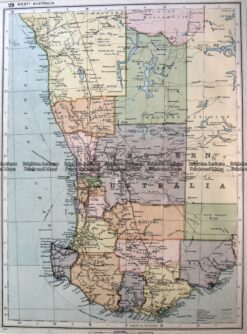
Western Australia from Australian Hand Book &;c.1886

Chromolithograph
24cm X 32cm
Condition B
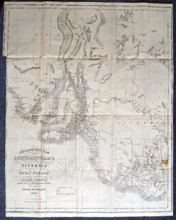

These may also be of interest

  • WA

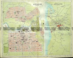
    Antique map – Street map of Adelaide c.1897 Ref# 232-885

    $140.00
  • 15-105 - Western Australia - North West John Sands - circa 1886 Chromolithograph 42cm X 52cm Condition A+
    Antique Maps

    Antique Map 15-105 – Western Australia – North West John Sands – circa 1886 Chromolithograph 42cm X 52cm Condition A+

    $250.00
  • 11-078 - South Australia - County of Adelaide J Sands - circa 1886 Chromolithograph 42cm X 52cm Condition A+
    Antique Maps

    Antique Map 11-078 – South Australia – County of Adelaide J Sands – circa 1886 Chromolithograph 42cm X 52cm Condition A+

    $225.00
  • WA

    Antique map – South Australia showing public works c.1894 Ref# 232-884

    $125.00
© 2025 BRIGHTON ANTIQUE PRINTS AND MAPS. ALL RIGHTS RESERVED | Website by Blaze Online
Credit Card
Norton Safe Web Transaction
  • Home
  • Catalogue
    • Antique Maps
    • Antique Prints
    • Books & Gov’t Reports
    • Manuscript Documents
  • Recent Arrivals
  • About
  • FAQ
  • Register Interests
  • Contact Us
  • View Cart
  • Login
  • Currency
    WOOCS 2.1.5
Brought to you by WisdmLabs: WordPress Development Experts

Sending...