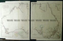
Brighton Antique Prints and Maps
Currency
WOOCS 2.1.5
VIEW CART
  • CURRENCY

    WOOCS 2.1.5
  • Home
  • Catalogue
    • Antique Maps
    • Antique Prints
    • Books & Gov’t Reports
    • Manuscript Documents
  • Recent Arrivals
  • About
  • FAQ
  • Register Interests
  • Contact Us
3-808

Home/Antique Maps/Australia & Pacific/Australia - Continent

Antique Map 3-808

SKU: 3-808 Categories: Antique Maps, Australia - Continent
3-805 County of Cumberland NSW by Basch circa 1872
3-022 - Australia - East Coast of Australia from Cooks first voyage Dutch edition van Baasel - circa 1774 Copperplate engraving with outline colour 78cm X 36cm Condition A+
  • Description
3-808 &;County of Roxburgh NSW from the first atlas printed in Australia

Hand coloured lithograph
52cm X 38cm
Condition A+

$425.00


These may also be of interest

  • 3-871 Australia by S.D.U.K c.1844
    Antique Maps

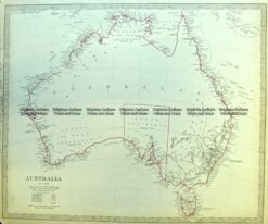
    Antique Map 3-871 Australia by S.D.U.K c.1844

    $350.00
  • 15-106 West Australia & Tasmania c.1844
    Antique Maps

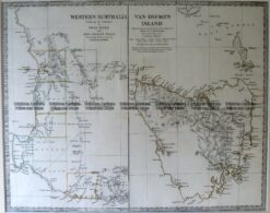
    Antique Map 15-106 West Australia & Tasmania c.1844

    $220.00
  • 9-973  Australia by Arrowsmith c.1842
    Antique Maps

    Antique Map 9-973 Australia by Arrowsmith c.1842

    $2,500.00
  • Antique Maps

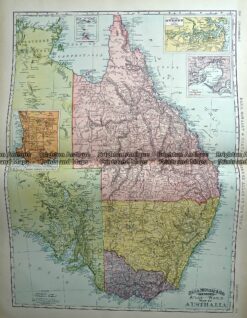
    Antique Map 233-225 Australia – Victoria, NSW, Queensland by Rand McNally c.1894

    $160.00
© 2026 BRIGHTON ANTIQUE PRINTS AND MAPS. ALL RIGHTS RESERVED | Website by Blaze Online
Credit Card
Norton Safe Web Transaction
  • Home
  • Catalogue
    • Antique Maps
    • Antique Prints
    • Books & Gov’t Reports
    • Manuscript Documents
  • Recent Arrivals
  • About
  • FAQ
  • Register Interests
  • Contact Us
  • View Cart
  • Login
  • Currency
    WOOCS 2.1.5

Sending...