Brighton Antique Prints and Maps
Currency
WOOCS 2.1.5
VIEW CART
  • CURRENCY

    WOOCS 2.1.5
  • Home
  • Catalogue
    • Antique Maps
    • Antique Prints
    • Books & Gov’t Reports
    • Manuscript Documents
  • Recent Arrivals
  • About
  • FAQ
  • Register Interests
  • Contact Us

Home/Antique Maps/Africa/Other

Showing all 3 results

Filter
  • 40-09 - Islands in the Atlantic Tallis  - circa 1851 Steel engraving 24cm X 33cm Condition A
    Antique Maps

    Antique Map 40-09 – Islands in the Atlantic Tallis – circa 1851 Steel engraving 24cm X 33cm Condition A

    $200.00
  • Antique Maps

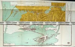
    Antique Map 232-121 Suez Canal by Gordon & Gotch c.1889

    $90.00
  • 40-05 - Africa - Madagascar Vander Aa  - circa 1735 Copperplate egraving 37cm X 29cm Condition A+
    SOLD
    Antique Maps

    Antique Map 40-05 – Africa – Madagascar Vander Aa – circa 1735 Copperplate egraving 37cm X 29cm Condition A+

Categories

  • Antique Maps
    • World
    • Australia & Pacific
    • Britain and Ireland
    • Europe
    • Asia
    • North America
    • South America
    • Africa
      • Africa - Continent
      • Eastern Africa
      • Northern Africa
      • Southern Africa
      • Western Africa
      • Other
    • City Street Maps
    • Geological maps
    • Tallis
  • Antique Prints
  • Books & Gov't Reports
  • Manuscript Documents

© 2025 BRIGHTON ANTIQUE PRINTS AND MAPS. ALL RIGHTS RESERVED | Website by Blaze Online
Credit Card
Norton Safe Web Transaction
  • Home
  • Catalogue
    • Antique Maps
    • Antique Prints
    • Books & Gov’t Reports
    • Manuscript Documents
  • Recent Arrivals
  • About
  • FAQ
  • Register Interests
  • Contact Us
  • View Cart
  • Login
  • Currency
    WOOCS 2.1.5