
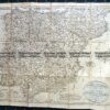
Navigation Chart of the Gallipoli area (Dardanelles) c.1912
Dardanelles just prior to W.W.I.
66cm X 100cm
Condition A (please disregard reflections caused by temporary plastic wrapping)

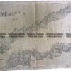
Navigation Chart of the Gallipoli area (Dardanelles) c.1912
Dardanelles just prior to W.W.I.
66cm X 100cm
Condition A (please disregard reflections caused by temporary plastic wrapping)
You must be logged in to post a comment.


Reviews
There are no reviews yet.