Brighton Antique Prints and Maps
Currency
WOOCS 2.1.5
VIEW CART
  • CURRENCY

    WOOCS 2.1.5
  • Home
  • Catalogue
    • Antique Maps
    • Antique Prints
    • Books & Gov’t Reports
    • Manuscript Documents
  • Recent Arrivals
  • About
  • FAQ
  • Register Interests
  • Contact Us
P1080205

Home/Antique Maps/World/World and Hemispheres

Antique Map 236-096 World c.1800

Categories: Antique Maps, World and Hemispheres
  • Description
  • Reviews (0)

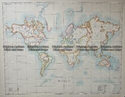
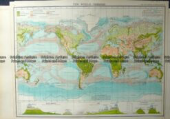
World on the Mercator Projection c.1800

Copperplate engraving with colour outline
110cm X 90cm
Condition A

Reviews


There are no reviews yet.

Be the first to review “Antique Map 236-096 World c.1800” Cancel reply

You must be logged in to post a comment.


These may also be of interest

  • Antarctica & Arctic

    Antique Map 233-392 World – showing distribution of birds and fishes by Weller c.1874

    $80.00
  • World and Hemispheres

    Vintage map – World Physiography by Bartholomew c.1958 Ref# 232-912

    $100.00
  • Antique Maps

    Antique Map 232-574 World – Population – Demographics by Bartholomew c.1900

    $75.00
  • 16-227 - World - Eastern & Western Hemispheres Pair of maps J Wyld - circa 1840 Hand coloured steel engraving 23cm X23cm Condition A+
    Antique Maps

    Antique Map 16-227 – World – Eastern & Western Hemispheres Pair of maps J Wyld – circa 1840 Hand coloured steel engraving 23cm X23cm Condition A+

    $290.00
© 2025 BRIGHTON ANTIQUE PRINTS AND MAPS. ALL RIGHTS RESERVED | Website by Blaze Online
Credit Card
Norton Safe Web Transaction
  • Home
  • Catalogue
    • Antique Maps
    • Antique Prints
    • Books & Gov’t Reports
    • Manuscript Documents
  • Recent Arrivals
  • About
  • FAQ
  • Register Interests
  • Contact Us
  • View Cart
  • Login
  • Currency
    WOOCS 2.1.5
Brought to you by WisdmLabs: WordPress Development Experts

Sending...