Brighton Antique Prints and Maps
Currency
WOOCS 2.1.5
VIEW CART
  • CURRENCY

    WOOCS 2.1.5
  • Home
  • Catalogue
    • Antique Maps
    • Antique Prints
    • Books & Gov’t Reports
    • Manuscript Documents
  • Recent Arrivals
  • About
  • FAQ
  • Register Interests
  • Contact Us
3-308  Victoria – Wonthaggi & Inverloch  c.1930

Home/Antique Maps/Australia & Pacific/Victoria

Antique Map 3-308 Victoria – Wonthaggi & Inverloch c.1930

SKU: 3-308 Categories: Antique Maps, Victoria
  • Description

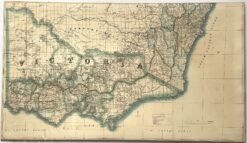
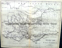
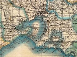
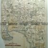
Victoria – Wonthaggi and Inverloch region prepared for Military &;c.1930

Lithograph
72cm X 47cm
Condition A


We have other maps of parts of Victoria prepared by the Australian Survey Corp


These may also be of interest

  • 14-218 - Victoria - Counties of Moira
    Antique Maps

    Antique Map 14-218 – Victoria – Counties of Moira, Delatite & Bogong John Sands – circa 1886 Chromolithograph 52cm X 42cm Condition A+

    $290.00
  • Victoria

    Antique Map – Road Map of Victoria by Robinson c.1930’s Ref No. 238-004

    $79.00
  • 14-220 - Victoria - County of Rodney F E Hiscock - circa 1874 Hand coloured lithograph 42cm X 49cm Condition A+
    Antique Maps

    Antique Map 14-220 – Victoria – County of Rodney F E Hiscock – circa 1874 Hand coloured lithograph 42cm X 49cm Condition A+

    $490.00
  • Antique Maps

    Antique Print Antique Map 233-233 Gold Mines in Victoria – Ballarat and Bendigo c.1880’s

    $50.00
© 2025 BRIGHTON ANTIQUE PRINTS AND MAPS. ALL RIGHTS RESERVED | Website by Blaze Online
Credit Card
Norton Safe Web Transaction
  • Home
  • Catalogue
    • Antique Maps
    • Antique Prints
    • Books & Gov’t Reports
    • Manuscript Documents
  • Recent Arrivals
  • About
  • FAQ
  • Register Interests
  • Contact Us
  • View Cart
  • Login
  • Currency
    WOOCS 2.1.5
Brought to you by WisdmLabs: WordPress Development Experts

Sending...