Brighton Antique Prints and Maps
Currency
WOOCS 2.1.5
VIEW CART
  • CURRENCY

    WOOCS 2.1.5
  • Home
  • Catalogue
    • Antique Maps
    • Antique Prints
    • Books & Gov’t Reports
    • Manuscript Documents
  • Recent Arrivals
  • About
  • FAQ
  • Register Interests
  • Contact Us
3-787 Australia by Bellin French edition

Home/Antique Maps/Australia & Pacific/Australia - Continent

Antique Map 3-787 Australia by Bellin French edition

SKU: 3-787 Categories: Antique Maps, Australia - Continent
3-524  Flinders chart of South Queensland  c.1814
3-820   World by Emanuel Bowen  c.1744
  • Description

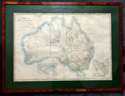
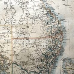
Australia – Carte Reduite des Terres Australes &;c.1753

Bellin, J &;circa 1753
Copperplate engraving
28cm X 21cm
Condition A+

&;


These may also be of interest

  • 3-101 - Northern Territory Vandermaelen - circa 1827 Hand coloured steel engraving 56cm X 47cm Condition A+
    Antique Maps

    Antique Map 3-101 – Northern Territory Vandermaelen – circa 1827 Hand coloured steel engraving 56cm X 47cm Condition A+

    $360.00
  • Antique Maps

    Antique Map 230-536 Carte de L’Oceanie by Malte Brun c.1836

    $280.00
  • 3-222 - Victoria - County of Evelyn F E Hiscock - circa 1874 Hand coloured lithograph 51cm X 40cm Condition A+
    Antique Maps

    Antique Map 3-222 – Victoria – County of Evelyn F E Hiscock – circa 1874 Hand coloured lithograph 51cm X 40cm Condition A+

    $490.00
  • Australia - Continent

    Antique map – Australia & New Zealand with shipping routes c.1913. Ref: 339-028

    $120.00
© 2025 BRIGHTON ANTIQUE PRINTS AND MAPS. ALL RIGHTS RESERVED | Website by Blaze Online
Credit Card
Norton Safe Web Transaction
  • Home
  • Catalogue
    • Antique Maps
    • Antique Prints
    • Books & Gov’t Reports
    • Manuscript Documents
  • Recent Arrivals
  • About
  • FAQ
  • Register Interests
  • Contact Us
  • View Cart
  • Login
  • Currency
    WOOCS 2.1.5
Brought to you by WisdmLabs: WordPress Development Experts

Sending...