Brighton Antique Prints and Maps
Currency
WOOCS 2.1.5
VIEW CART
  • CURRENCY

    WOOCS 2.1.5
  • Home
  • Catalogue
    • Antique Maps
    • Antique Prints
    • Books & Gov’t Reports
    • Manuscript Documents
  • Recent Arrivals
  • About
  • FAQ
  • Register Interests
  • Contact Us
3-818 Coast of Queensland by Flinders Admiralty Chart 1814

Home/Antique Maps/Australia & Pacific/Australia - Continent

Antique Map 3-818 Coast of Queensland by Flinders Admiralty Chart 1814

SKU: 3-818 Categories: Antique Maps, Australia - Continent
9-072 - Sydney Sydney Morning Herald - circa 1938 Offset printing 59cm X 47cm Condition A+ -   -
3-803 Australia by Djurberg
  • Description

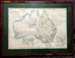
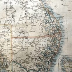
3-818 Flinders East Coast Chart III circa 1814
Hervey Bay to Northumberland Is.&;

Copperplate engraving
90cm X 62cm Condition

SOLD


These may also be of interest

  • Antique Maps

    Antique Map 230-540 Australian oder Oceanien by Koehler c.1849

    $290.00
  • 3-073 - New South Wales J Bartholomew circa 1848 Hand coloured steel engraving 27cm X 38cm Condition A+
    Antique Maps

    Antique Map 3-073 – New South Wales J Bartholomew circa 1848 Hand coloured steel engraving 27cm X 38cm Condition A+

    $190.00
  • Antique Maps

    Antique Map 230-539 Australia by Migeon c.1865

    $290.00
  • 3-091 - Tasmania Johnston - circa 1845 Steel engraving 49cm X 59cm Condition A+
    Antique Maps

    Antique Map 3-091 – Tasmania Johnston – circa 1845 Steel engraving 49cm X 59cm Condition A+

    $480.00
© 2025 BRIGHTON ANTIQUE PRINTS AND MAPS. ALL RIGHTS RESERVED | Website by Blaze Online
Credit Card
Norton Safe Web Transaction
  • Home
  • Catalogue
    • Antique Maps
    • Antique Prints
    • Books & Gov’t Reports
    • Manuscript Documents
  • Recent Arrivals
  • About
  • FAQ
  • Register Interests
  • Contact Us
  • View Cart
  • Login
  • Currency
    WOOCS 2.1.5

Sending...