CURRENCY
$275.00
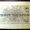
New South Wales by S.D.U.K. c.1844
Steel engraving 33cm X 39cm Condition B (light stains in left border)
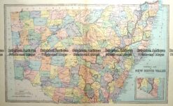
Antique map – New South Wales c.1886 Ref: 889-003
Antique Map 232-106 Navigation Charts corrected to 1940’s
Antique Map 9-066 – Botany Bay / Endeavour River J Cook – circa 1774 Copperplate engraving 33cm X 13cm Condition A+
Antique Map 9-064 – New South Wales Picturesque Atlas – circa 1886 Chromolithograph 61cm X 37cm Condition A+