Brighton Antique Prints and Maps
Currency
WOOCS 2.1.5
VIEW CART
  • CURRENCY

    WOOCS 2.1.5
  • Home
  • Catalogue
    • Antique Maps
    • Antique Prints
    • Books & Gov’t Reports
    • Manuscript Documents
  • Recent Arrivals
  • About
  • FAQ
  • Register Interests
  • Contact Us

Home/Antique Maps/Australia & Pacific/Pacific

Showing all 42 results

Filter
  • Australia - Continent

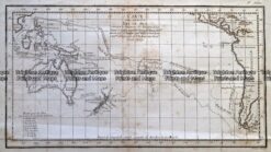
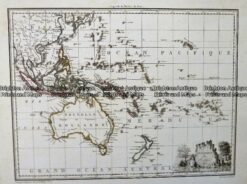
    Antique Map – Oceanique Orient by Tardieu c.1812 Ref: 237-153

    $400.00
  • Antique Maps

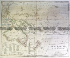
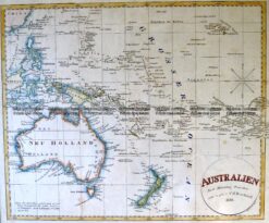
    Antique Map 230-540 Australian oder Oceanien by Koehler c.1849

    $290.00
  • Pacific

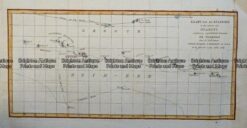
    Antique Map – Kaart van de Eilanden in den omtrek van Otahiti c.1803 Ref: 237-147

    $280.00
  • Antique Maps

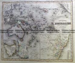
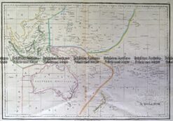
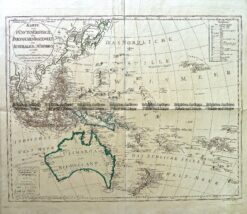
    Antique Map 230-542 Neueste Karte von Australien by Radefeld c.1846

    $280.00
  • Antique Maps

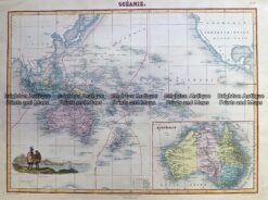
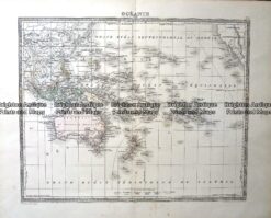
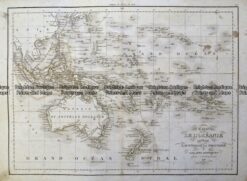
    Antique Map 230-536 Carte de L’Oceanie by Malte Brun c.1836

    $280.00
  • Antique Maps

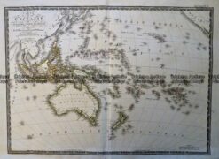
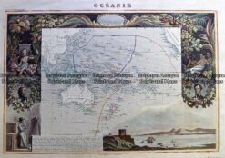
    Antique Map 230-531 Oceanie by Migeon c.1878

    $280.00
  • Antique Maps

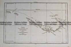
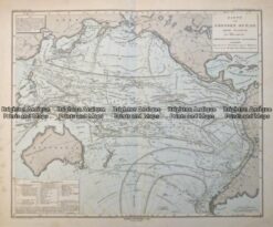
    Antique Map 232-271 Carte d’une Partie de la Mer du Sud Contentant

    $250.00
  • Pacific

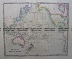
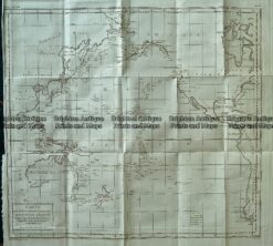
    Antique map – Pacific Ocean by Playfair c.1822. Ref: 339-013

    $220.00
  • Australia - Continent

    Antique Map – Oceanie Pacific by Lemercier c.1850 Ref: 237-367

    $220.00
  • Pacific

    Isle Norfolk by Benard c.1778 Ref: 237-149

    $220.00
  • Australia - Continent

    Antique Map – Pacific and Australia by Teasdale c.1847

    $220.00
  • 3-699  Oceania - Australia and Pacific by Johnston c.1864
    Antique Maps

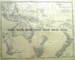
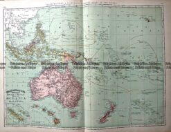
    Antique Map 3-699 Oceania – Australia and Pacific by Johnston c.1864

    $220.00
  • 3-009 - Australia - Oceania Picturesque Atlas - circa 1886 Chromolithograph 61cm X 37cm Condition A+
    Antique Maps

    Antique Map 3-009 – Australia – Oceania Picturesque Atlas – circa 1886 Chromolithograph 61cm X 37cm Condition A+

    $220.00
  • Pacific

    Antique Map – Copie d’une partie de la Carte de Dampier c.1787Ref: 237-148

    $160.00
  • Pacific

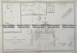
    Antique Map – Isles de la Reine Charlotte by Bonne c.1787 Ref: 237-141

    $150.00
  • Antique Maps

    Antique Map 233-025 Oceania by Rand McNally c.1894

    $150.00
  • Antique Maps

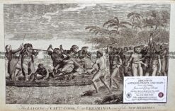
    Antique Print Antique Map 232-448 Captain Cook in Erramanga, New Hebrides c.1777

    $150.00
  • Antique Maps

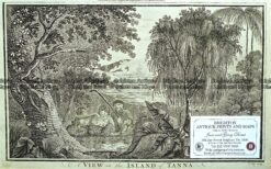
    Antique Print Antique Map 232-447 Island of Tanna – Cook’s voyage c.1777

    $150.00
  • Antique Maps

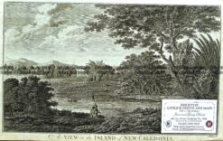
    Antique Print Antique Map 232-446 New Caledonia – Cook’s voyage c.1777

    $150.00
  • 7-068  Fiji  c.  1883
    Antique Maps

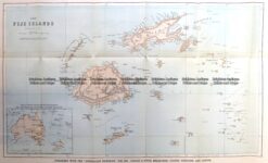
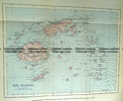
    Antique Map 7-068 Fiji c. 1883

    $140.00
  • Pacific

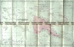
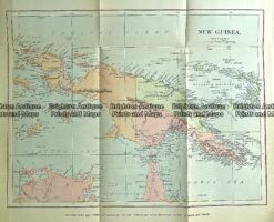
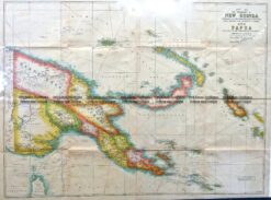
    Antique map – New Guinea c.1884 Ref# 232-893

    $125.00
  • Australia & Pacific

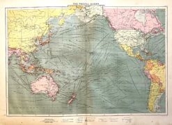
    Antique map – Australia and Pacific Ocean with shipping routes 1913. Ref: 339-027

    $120.00
  • Antique Maps

    Antique Map 232-118 Fiji by Gordon & Gotch c.1889

    $90.00
  • Antique Maps

    Antique Map 232-115 New Guinea by Gordon & Gotch c.1889

    $90.00
  • Antique Maps

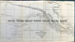
    Antique Map 232-106 Navigation Charts corrected to 1940’s

    $50.00
  • SOLD
    Antique Maps

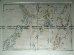
    Antique Map 230-113 New Zealand, New Guinea & Hawaii c.1860

  • SOLD
    Australia - Continent

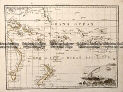
    Oceanique by Lapie c.1812 Ref: 237-152

  • SOLD
    Pacific

    Antique Map – Carte de l’océanie Cinquième Partie du Monde by Brue c.1820 Ref: 237-151

  • SOLD
    Pacific

    Antique Map – Carte vom Grossen Ocean by Perthes c.1849 Ref: 237-144

  • SOLD
    Australia - Continent

    Antique Map – Carte de l’oceania by Delamarche c.1838 Ref: 237-143

  • SOLD
    Antique Maps

    Antique Map 233-017 Carte Mer du Sud – Australia and Pacific c.1775

  • SOLD
    Antique Maps

    Antique Map 232-276 Pacific – De l’Aiguille Aimantee by Poirson c.1780

  • SOLD
    Antique Maps

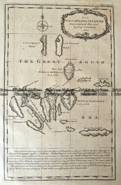
    Antique Map 232-001 Gallapagos Islands by Emanuel Bowen c.1744

  • SOLD
    Antique Maps

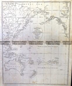
    Antique Map 230-545 Accurate Chart of the discoveries of Capt Cook by Lodge c.1797

  • SOLD
    Antique Maps

    Antique Map 230-541 Oceanie by Levasseur c.1845

  • SOLD
    Antique Maps

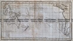
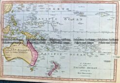
    Antique Map 230-532 Chart of the Pacific by Robinson c.1810

  • SOLD
    Antique Maps

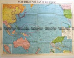
    Antique Map 230-510 Pacific c.1940’s printed by Daily Express

  • 3-821  Australia by Canzler c.1795
    SOLD
    Antique Maps

    Antique Map 3-821 Australia by Canzler c.1795

  • 7-070  New Guinea c.1944
    SOLD
    Antique Maps

    Antique Map 7-070 New Guinea c.1944

  • 7-069 New Guinea  c.1881
    SOLD
    Antique Maps

    Antique Map 7-069 New Guinea c.1881

  • 3-866  Australia by C G Reichard c. 1816
    SOLD
    Antique Maps

    Antique Map 3-866 Australia by C G Reichard c. 1816

  • 3-765 Polynesia by Tallis
    SOLD
    Antique Maps

    Antique Map 3-765 Polynesia by Tallis

Categories

  • Antique Maps
    • World
    • Australia & Pacific
      • Australia - Continent
      • Victoria
      • Victorian Parish & Military Maps
      • Victorian Geological Maps
      • Melbourne
      • NSW
      • Tasmania
      • Queensland
      • WA, SA & NT
      • New Zealand
      • Pacific
    • Britain and Ireland
    • Europe
    • Asia
    • North America
    • South America
    • Africa
    • City Street Maps
    • Geological maps
    • Tallis
  • Antique Prints
  • Books & Gov't Reports
  • Manuscript Documents

© 2025 BRIGHTON ANTIQUE PRINTS AND MAPS. ALL RIGHTS RESERVED | Website by Blaze Online
Credit Card
Norton Safe Web Transaction
  • Home
  • Catalogue
    • Antique Maps
    • Antique Prints
    • Books & Gov’t Reports
    • Manuscript Documents
  • Recent Arrivals
  • About
  • FAQ
  • Register Interests
  • Contact Us
  • View Cart
  • Login
  • Currency
    WOOCS 2.1.5