Brighton Antique Prints and Maps
Currency
WOOCS 2.1.5
VIEW CART
  • CURRENCY

    WOOCS 2.1.5
  • Home
  • Catalogue
    • Antique Maps
    • Antique Prints
    • Books & Gov’t Reports
    • Manuscript Documents
  • Recent Arrivals
  • About
  • FAQ
  • Register Interests
  • Contact Us

Home/Antique Maps/World/Thematic

Showing all 26 results

Filter
  • 16-260  World - Admiralty chart - Wind chart  c.1879
    Antique Maps

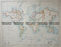
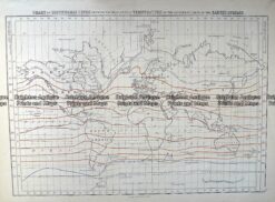
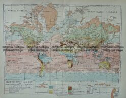
    Antique Map 16-260 World – Admiralty chart – Wind chart c.1879

    $290.00
  • 16-232 - World - World Climate Zones Anon - circa 1760 Hand coloured copperplate engraving 56cm X 32cm Condition A+
    Antique Maps

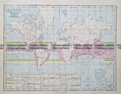
    Antique Map 16-232 – World – World Climate Zones Anon – circa 1760 Hand coloured copperplate engraving 56cm X 32cm Condition A+

    $220.00
  • Antique Maps

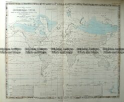
    Antique Map 232-572 World – Isothermal Lines by Johnston c.1850

    $180.00
  • Antique Maps

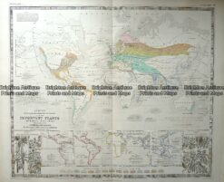
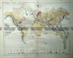
    Antique Map 232-571 World – plants of the world by Johnston c.1850

    $180.00
  • Antique Maps

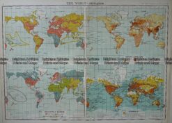
    Antique Map 232-574 World – Religions by Bartholomew c.1900

    $120.00
  • Antique Maps

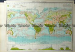
    Antique Map 232-573 World – Vegetation by Bartholomew c.1900

    $120.00
  • Antique Maps

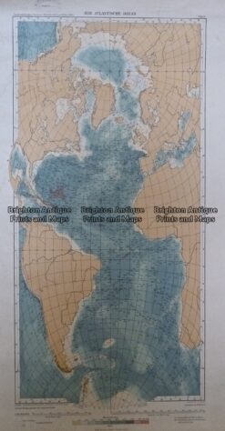
    Antique Map 233-238 Der Atlantische Ozean c.1912

    $110.00
  • Antique Maps

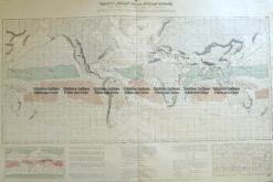
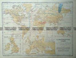
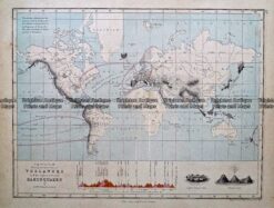
    Antique Map 232-583 World – Climatological by Johnston c.1851

    $85.00
  • Antique Maps

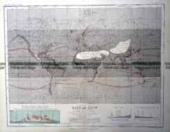
    Antique Map 232-582 World – Rain and Snow by Johnston c.1851

    $85.00
  • Antique Maps

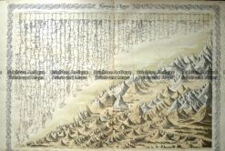
    Antique Map 232-581 Asia – Mountains and tablelands c.1851

    $85.00
  • Antique Maps

    Antique Map 232-580 World – Earthquakes and Volcanoes c.1880

    $85.00
  • Antique Maps

    Antique Map 233-395 World – showing Volcanoes and Earthquakes

    $80.00
  • Antique Maps

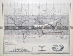
    Antique Map 233-394 World – distribution of Rain and Snow by Weller c.1874

    $80.00
  • Antique Maps

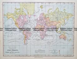
    Antique Map 233-393 World – showing Ocean currents by Weller c.1874

    $80.00
  • Antarctica & Arctic

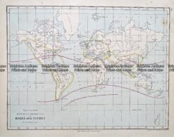
    Antique Map 233-392 World – showing distribution of birds and fishes by Weller c.1874

    $80.00
  • Antique Maps

    Antique Map 233-391 World – showing winds by Weller c.1874

    $80.00
  • Antique Maps

    Antique Map 232-575 World – Isothermal Lines by Black c.1862

    $80.00
  • Antique Maps

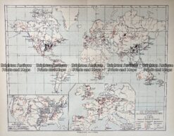
    Antique Map 232-574 World – Population – Demographics by Bartholomew c.1900

    $75.00
  • Antique Maps

    Antique Map 2342-572 World – climate by Bartholomew c.1900

    $75.00
  • Antique Maps

    Antique Map 232-575 World – Hauptklimate der Erde c.1905

    $60.00
  • SOLD
    Antique Maps

    Antique Map 232-584 World Mountains and Rivers – height and length c.1855

  • SOLD
    Antique Maps

    Antique Map 232-576 World – Mineralfundstatten auf der Erde c.1905

  • SOLD
    Thematic

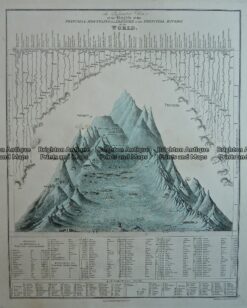
    Antique Map – A Comparative Chart of Principal Mountains and Rivers c.1847 Ref: 237-130

  • SOLD
    Antique Maps

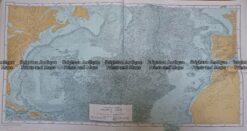
    Antique Map 233-239 Atlantic Ocean by B. Heezen & M. Tharp c.1957

  • SOLD
    Antique Maps

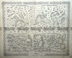
    Antique Map 232-585 World – Comparative size of Lakes and Islands by Colton c.1855

  • 3-816  World with Currents of Air  c.1850
    SOLD
    Antique Maps

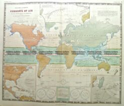
    Antique Map 3-816 World with Currents of Air c.1850

Categories

  • Antique Maps
    • World
      • World and Hemispheres
      • Antarctica & Arctic
      • Thematic
      • Celestial
    • Australia & Pacific
    • Britain and Ireland
    • Europe
    • Asia
    • North America
    • South America
    • Africa
    • City Street Maps
    • Geological maps
    • Tallis
  • Antique Prints
  • Books & Gov't Reports
  • Manuscript Documents

© 2025 BRIGHTON ANTIQUE PRINTS AND MAPS. ALL RIGHTS RESERVED | Website by Blaze Online
Credit Card
Norton Safe Web Transaction
  • Home
  • Catalogue
    • Antique Maps
    • Antique Prints
    • Books & Gov’t Reports
    • Manuscript Documents
  • Recent Arrivals
  • About
  • FAQ
  • Register Interests
  • Contact Us
  • View Cart
  • Login
  • Currency
    WOOCS 2.1.5