
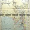
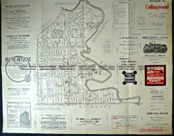
Navigation Chart of Port Melbourne c.1982
(entrance to Melbourne and streets near Hobson’s Bay)
66cm X 93cm
Condition A+

Home/Antique Maps/Australia & Pacific/Melbourne
Antique Map 232-088 Navigation Chart – Port of Melbourne c.1982
Be the first to review “Antique Map 232-088 Navigation Chart – Port of Melbourne c.1982”
You must be logged in to post a comment.

Reviews
There are no reviews yet.