Skip to content
Brighton Antique Prints and MapsBrighton Antique Prints and Maps
  • CURRENCY

    WOOCS 2.1.5
  • VIEW CART
  • Catalogue
  • Home
  • Catalogue
    • Antique Maps
    • Antique Prints
    • Books & Gov’t Reports
    • Manuscript Documents
  • Recent Arrivals
  • About
  • FAQ
  • Register Interests
  • Contact Us
Antique Map 232-167  Nouvelle Zemble by Mallet c.1683
Home / Antique Maps / Europe / Russia
  • 2-157  Tallis map of Indonesia and S. E. Asia

Antique Map 232-167 Nouvelle Zemble by Mallet c.1683

  • 2-157  Tallis map of Indonesia and S. E. Asia

$90.00

Categories: Antique Maps, Russia
  • 2-157  Tallis map of Indonesia and S. E. Asia
Product Categories
  • Antique Maps
    • World
    • Australia & Pacific
    • Britain and Ireland
    • Europe
      • Europe - Continent
      • France
      • Germany
      • Italy
      • Greece
      • Holland & Belgium
      • Poland & Baltic
      • Balkans
      • Spain & Portugal
      • Scandinavia
      • Switzerland
      • Russia
      • Turkey
      • Other
    • Asia
    • North America
    • South America
    • Africa
    • City Street Maps
    • Geological maps
    • Tallis
  • Antique Prints
  • Books & Gov't Reports
  • Manuscript Documents
  • Description
  • Reviews (0)

Northern Russia – Nouvelle Semble by Allain Mallet c.1683

Hand coloured copperplate engraving
10cm X 15cm
Condition A+

Reviews

There are no reviews yet.

Be the first to review “Antique Map 232-167 Nouvelle Zemble by Mallet c.1683” Cancel reply

You must be logged in to post a review.

These may also be of interest

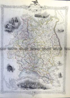
5-236 Russia - Northern region of Russia in Europe by S.D.U.K  c.1844

Antique Map 5-236 Russia – Northern region of Russia in Europe by S.D.U.K c.1844

$140.00
5-245  Russia in Europe by Tallis  c.1851

Antique Map 5-245 Russia in Europe by Tallis c.1851

$200.00
Antique Map 232-061  Russia - Russian Empire in Europe and Asia by Bowen  c.1744

Antique Map 232-061 Russia – Russian Empire in Europe and Asia by Bowen c.1744

$275.00
Placeholder

Antique Map 232-106 Navigation Charts corrected to 1940’s

$50.00
© 2026 BRIGHTON ANTIQUE PRINTS AND MAPS. ALL RIGHTS RESERVED | Website by Blaze Online Credit Card
Visa
PayPal
Stripe
MasterCard
Cash On Delivery
  • Home
  • Catalogue
    • Antique Maps
    • Antique Prints
    • Books & Gov’t Reports
    • Manuscript Documents
  • Recent Arrivals
  • About
  • FAQ
  • Register Interests
  • Contact Us
  • View Cart

Sending...