Brighton Antique Prints and Maps
Currency
WOOCS 2.1.5
VIEW CART
  • CURRENCY

    WOOCS 2.1.5
  • Home
  • Catalogue
    • Antique Maps
    • Antique Prints
    • Books & Gov’t Reports
    • Manuscript Documents
  • Recent Arrivals
  • About
  • FAQ
  • Register Interests
  • Contact Us
4-184  London panorama 1842

Home/Antique Maps/Britain and Ireland/England

Antique Map 4-184 London panorama 1842

SKU: 4-184-2 Categories: Antique Maps, City Street Maps, England
3-787 Australia by Bellin French edition
5-045 - Romania Ortelius - circa 1580 Hand coloured copperplate engraving 50cm X 36cm Condition A+
  • Description

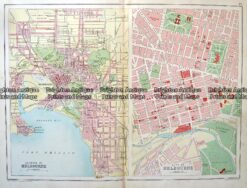
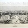
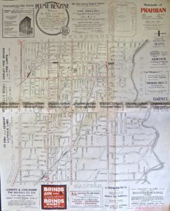
Panorama of London c.1842
– two parts that can be joined – see previous listing

Wood engraving&;
121cm X 30cm
Condition A+

&;


These may also be of interest

  • 4-186 County of Suffolk England c.1847
    Antique Maps

    Antique Map 4-186 County of Suffolk England c.1846

    $195.00
  • City Street Maps

    Antique map – Derby Street Map by Verner, Hood & Sharpe c.1805 Ref#232-739

    $130.00
  • 5-166 - England - Isle of Thanet Moule - circa 1840 Hand coloured steel engraving 26cm X 19cm Condition A+
    Antique Maps

    Antique Map 5-166 – England – Isle of Thanet Moule – circa 1840 Hand coloured steel engraving 26cm X 19cm Condition A+

    $240.00
  • 9-162  St Kilda street map c.1920
    Antique Maps

    Antique Map 9-162 St Kilda street map c.1920

    $69.00
© 2026 BRIGHTON ANTIQUE PRINTS AND MAPS. ALL RIGHTS RESERVED | Website by Blaze Online
Credit Card
Norton Safe Web Transaction
  • Home
  • Catalogue
    • Antique Maps
    • Antique Prints
    • Books & Gov’t Reports
    • Manuscript Documents
  • Recent Arrivals
  • About
  • FAQ
  • Register Interests
  • Contact Us
  • View Cart
  • Login
  • Currency
    WOOCS 2.1.5

Sending...