


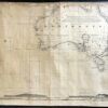
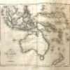
Navigation chart including Africa, Australia, New Zealand and Indian Ocean c.1850.
This is a special nautical chart because of its age and excellent condition.
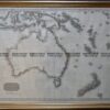
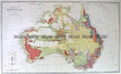
The map is a blueback maritime map that includes Africa and New Zealand and everything in between. It also features coastal profiles. It pre-dates the gold rush that prompted a “people rush” to Australia. The publisher was Norie & Wilson. The chart would look superb on any long wall or in a hallway. It measures 203cm (78 inches) long and 60 cm (24 inches) high. Alternatively, you could unroll the map whenever you wish to enjoy it. The length makes it difficult to photograph so I am attaching close-up of Australia. Note that Victoria is identified as Australia Felix, as the map was prepared before Victoria separated from New South Wales in 1851. West Australia is referred to as a colony. The land details in this map are exceptional for a nautical chart.
Reviews
There are no reviews yet.