
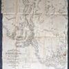
Navigation Admiralty Chart of the West Channel at the entrance of Port Phillip. 1903 corrected to 1961. Queenscliff on the bottom left.
Sheet size approx 70cm X 52cm.
Condition A

$100.00
Navigation Admiralty Chart of the West Channel at the entrance of Port Phillip. 1903 corrected to 1961. Queenscliff on the bottom left.
Sheet size approx 70cm X 52cm.
Condition A
You must be logged in to post a comment.

Reviews
There are no reviews yet.