

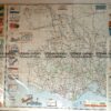
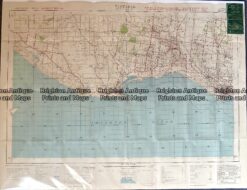
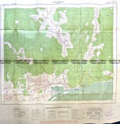
Military and Lands & Survey maps 20th century
Approx 90cm X 60cm
Condition varies
See list below
Most maps are priced between $50 and $100.
REGION OF VICTORIA AND SCALE
Alberton – Yarram, Port Albert, Tarraville 1942 1 mile to 1″
Anglesea – Anglesea, Torquay, Aireys Inlet (on Web) 1925/1956 1 mile to 1″
Bairnsdale – Bairnsdale, Lakes Entrance 1942 1 mile to 1″
Ballan – Ballan, Bacchus Marsh, Werribee River (folded)
Ballan Sunbury Meredith and Western suburbs (folded)
Ballarat – Ballarat, Lake Burrumbeet, Linton (folded) 1942/1971 4 miles to 1″
Beeac – Lake Beeac, Lake Murneduke 1949
Bendigo – Bendigo, Echuca, Shepparton, Nagambie 1943/1967 4 miles to 1″
Carrajung – Carrajung 1943 1 mile to 1″
Castlemaine – Castlemaine, Malmsbury, Elphinstone 1955 1 mile to 1″
Colac – Colac, Camperdown, Mortlake, Terang 1942 1 & 4 Miles to 1″
Cranbourne – Cranbourne, Frankston, Berwick, Packenham (on Web) 1924 1 mile to 1″
Deal Island – Bass Strait, Kent Group, Hogan Group, Wilsons Prom 1967 1:250,000
Foster – Foster, Toora, Fishcreek, Dumbalk 1943/1971 1 mile to 1″ 100000
Geelong – Geelong, Inverleigh, Corio Bay (on Web) 1955 1 mile to 1″
Gembrook – Gembrook, Warburton, Yarra Junction, Powelltown 1966 1:50,000
Glenaire – Otway National Park 1970? 1:25,000
Glenburn – Glenburn, Flowerdale, Yea River 1958 1:50,000
Hamilton – Hamilton, Dunkeld, Casterton, Grampians 1942 4 miles to 1″
Hartland 1942 1 mile to 1″
Healsville – Healsville, Gembrook, Warburton 1970 1:100,000
Jamieson – Eildon Weir, Mount Terrible 1964 1:50,000
Juliet – Great Dividing Range, Maroondah Reservoir, Healesville 1964 1:50,000
Kinglake – Kinglake, Flowerdale 1958 1:50,000
Korumburra – Korumburra, Leongatha, Lang Lang 1931 1 mile to 1″
Lancefield – Lancefield, Woodend, Macedon, Kilmore
Liptrap – Cape Liptrap 1929 1 mile to 1″
McMahons Creek – Upper Yarra Reservoir, Great Dividing, 1964 1:50,000
Mallacoota – Mallacoota, eastern part of Victoria 1968 1:250,000
Matlock – Great Dividing Range, Frenchman Spur, Thomson Rv 1964 1:50,000
Melbourne – Western suburbs, Werribee, Altona, Sunshine. Also folded 1933 1 mile to 1″
Melbourne – Melbourne, Seymour, Castlemaine, Lilydale, Ballan 1957 1:250,000
Meredith – Meridith, Lethbridge. Also folded. 1953 1 mile to 1″
Mildura – Mildura, 1959 1:250,000
Mirboo North – Mirboo North Boolarra, Thorpdale 1941 1 mile to 1″
Moe – Moe, Yallourn, Morwell (on Web) 1940 1 mile to 1″
Monbulk – Mooroolbark, Croydon, Lower Ferntree Gully, Upwey 1960 1: 50,000
Nagambie – Nagambie, Avenel, Longwood, Goulburn River (folded) 1953/1961 1 mile to 1″ 50,000
Neerim – Powelltown, Noojee, LaTrobe River, Tarago River 1966 1:50,000
Nelson – West of Portland 1943/1967 1 mile to 1″ 1:50,000
Nhill – Nhill, Lake Hindmarsh, Jeparit 1976 1:100,000
Orbost – Orbost, Lake Tyers 1976 1:100,000
Phillip Island 1:25,000
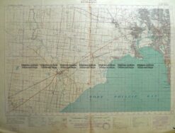
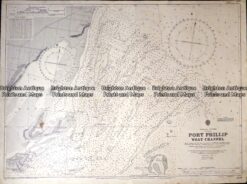
Port Phillip – Port Phillip Heads, Mornington Peninsula, Geelong (backed) 1966
Portarlington – Portarlington, Drysdale 1955 1 mile to 1″
Portland – Portland, Heywood 1941/1966 4miles to 1″ 1:100,000
Queenscliff – Queenscliff, Rosebud, Mornington Peninsula 1966 1:250,000
Ringwood – Ringwood, Dandenong, S E Suburbs (on Web). Also folded 1922 1 mile to 1″
Rokewood – Rokewood (folded)
St Arnaud – St Arnaud, 1970 1:100,000
Sale – Sale, Lake Wellington, Lake Victoria, Ninety Mile Beach 1938/1968 1 mile to 1″ 100000
Sorrento – Mornington , Rosebud, Rye, Portsea, Queesncliff (backed)
Skene – Jamieson River, Great Dividing Range, Mountain Ash 1964 1:50,000
Stockyard – Lake Victoria 1941 1 mile to 1″
Stradbroke – Ninety Mile Beach 1942 1 mile to 1″
Sunbury – Sunbury, North West suburbs, Melton (folded) 1938 1mile to 1″
Tallangatta – Lake Hume, Mount Beauty, Great Dividing Range 1968 1:250,000
Tallarook – Tallarook, Seymour, Broadford, Yea, Goulburn River (folded) 1961 1:50,000
Thornton – Thornton, Eildon Wier, Royston River 1967 1:50,000
Wangaratta – Wangaratta, Albury, Benalla, Beechworth 1968 1:250,000
Wangerrip – Otway National Park, State Park 1984 1:25,000
Warburton – Warburton, Lake Eildon, Maffra, Mansfield, Mt Buller 1942/1975 4 miles to 1″ 1:250,000
Warragul – Warragul, Morwell, Leongatha, Alberton, Wilson’s 1942 4 miles to 1″
Western Port – Flinders, Cowes, Corinella 1939 1 mile to 1″
Willaura – Willaura, Glenthompson, Lake Bolac 1968 1:100,000
Wilson’s Promontory – Wilson’s Promontory, Bass Strait 1942/1975 1 mile to 1″ 1:100000
Wonthaggi – Wonthaggi, Inverloch (on Web) 1930 1 mile to 1″
Woolamai – Phillip Island (south) 1940 1 mile to 1″
Yackandandah -Yackandandah, Bruarong, Mudgeegonga 1965 1:50,000
Yan Yean – Yan Yean, Yarra River, Eltham, Yarra Glen, Wonga Park (folded) 1935 1 mile to 1″
Yanakie – Shallow Inlet, Corner Inlet (North of Wilson’s Prom 1942 1 mile to 1″
Yarram – Yarram, Port Albert, Ninety Mile Beach 1975 1:100,000
Yea – Yea 1:50,000
Reviews
There are no reviews yet.