Brighton Antique Prints and Maps
Currency
WOOCS 2.1.5
VIEW CART
  • CURRENCY

    WOOCS 2.1.5
  • Home
  • Catalogue
    • Antique Maps
    • Antique Prints
    • Books & Gov’t Reports
    • Manuscript Documents
  • Recent Arrivals
  • About
  • FAQ
  • Register Interests
  • Contact Us

Home/Antique Maps/Britain and Ireland/Wales

Showing all 29 results

Filter
  • 4-174  England and Wales by Chatelain c.1719
    Antique Maps

    Antique Map 4-174 England and Wales by Chatelain c.1719

    $625.00
  • 5-142 - England (LAngleterre) Dufour - circa 1856 Steel engraving 75cm X 55cm Condition A+
    Antique Maps

    Antique Map 5-142 – England (LAngleterre) Dufour – circa 1856 Steel engraving 75cm X 55cm Condition A+

    $380.00
  • Antique Maps

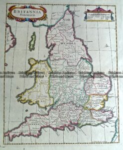
    Antique Map 232-171 Britannia Saxonica by Morden c.1695

    $350.00
  • Antique Maps

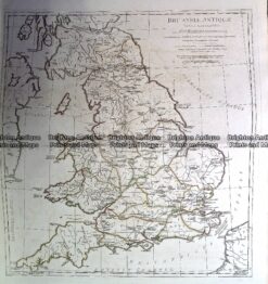
    Antique Map 230-139 Britain – Britanniae Antiquae by D’Anville c.1785

    $350.00
  • 4-201  Wales - northern Counties by Walker  c.1824
    Antique Maps

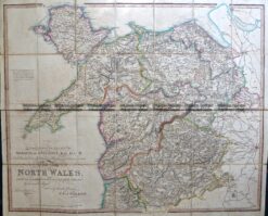
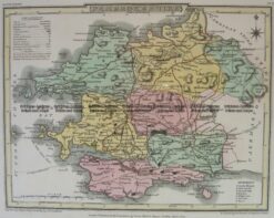
    Antique Map 4-201 Wales – northern Counties by Walker c.1824

    $325.00
  • 4-183  England and Wales by Robert c.1753
    Antique Maps

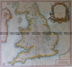
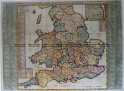
    Antique Map 4-183 England and Wales by Robert c.1753

    $325.00
  • 5-141 - England and Wales Downer - circa 1840 Hand coloured steel engraving 21cm X 26cm Condition A+
    Antique Maps

    Antique Map 5-141 – England and Wales Downer – circa 1840 Hand coloured steel engraving 21cm X 26cm Condition A+

    $250.00
  • England

    Antique Map – England by Kitchin c.1780 Ref: 237-363

    $225.00
  • 4-167  Ancient England and Wales  c.1844
    Antique Maps

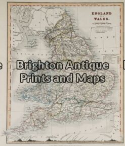
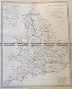
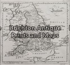
    Antique Map 4-167 Ancient England and Wales c.1844

    $150.00
  • Antique Maps

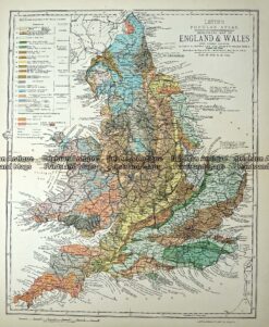
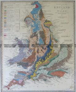
    Antique Map 233-365 Geological map of England and Wales by Letts c.1880

    $140.00
  • 4-185  Wales - north by S.D.U.K.  c.1844
    Antique Maps

    Antique Map 4-185 Wales – north by S.D.U.K. c.1844

    $140.00
  • 4-140 - England and Wales George Virtue - circa 1840 Hand coloured steel engraving 20cm X 25cm Condition A+
    Antique Maps

    Antique Map 4-140 – England and Wales George Virtue – circa 1840 Hand coloured steel engraving 20cm X 25cm Condition A+

    $140.00
  • 4-198  Wales - Southern Counties by Longman  c.1836
    Antique Maps

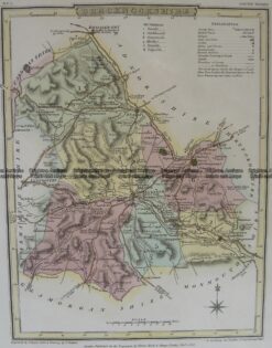
    Antique Map 4-198 Wales – Southern Counties by Longman c.1836

    $130.00
  • Antique Maps

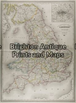
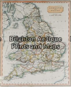
    Antique Map 232-154 England & Wales by Lewis c.1846

    $125.00
  • 4-208 Wales Radnorshire  by J Roper  c.1809
    Antique Maps

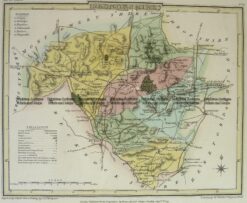
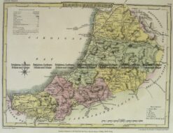
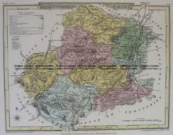
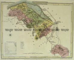
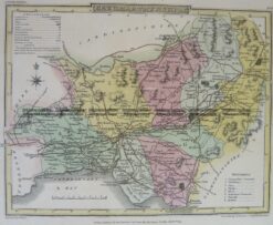
    Antique Map 4-208 Wales Radnorshire by J Roper c.1809

    $125.00
  • 4-207  Wales Cardiganshire  by J Roper  c.1809
    Antique Maps

    Antique Map 4-207 Wales Cardiganshire by J Roper c.1809

    $125.00
  • 4-205  Wales Montgomeryshire  by J Roper  c.1809
    Antique Maps

    Antique Map 4-205 Wales Montgomeryshire by J Roper c.1809

    $125.00
  • 4-204  Wales Flintshire  by J Roper  c.1809
    Antique Maps

    Antique Map 4-204 Wales Flintshire by J Roper c.1809

    $125.00
  • 4-202  Wales Caermarthenshire  by J Roper  c.1809
    Antique Maps

    Antique Map 4-202 Wales Caermarthenshire by J Roper c.1809

    $125.00
  • 4-201  Wales Brecknockshire  by J Roper  c.1809
    Antique Maps

    Antique Map 4-201 Wales Brecknockshire by J Roper c.1809

    $125.00
  • 4-199  Wales Pembrokeshire  by J Roper  c.1809
    Antique Maps

    Antique Map 4-199 Wales Pembrokeshire by J Roper c.1809

    $125.00
  • Antique Maps

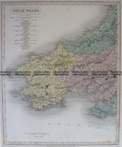
    Antique Map 233-294 England and Wales – South West by Stanford c.1887

    $100.00
  • Wales

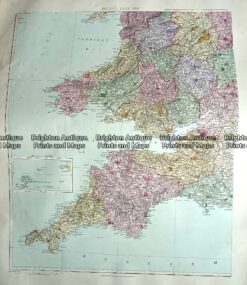
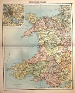
    Antique map – Wales by Bartholomew c.1898. Ref: 339-010

    $80.00
  • Antique Maps

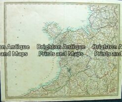
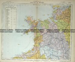
    Antique Map 233-364 Wales – northern by Letts c.1880

    $70.00
  • SOLD
    Antique Maps

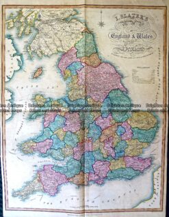
    Antique Map 230-488 England and Wales by Slater c.1846

  • 4-180  England Geological map by S.D.U.K. c.1844
    SOLD
    Antique Maps

    Antique Map 4-180 England Geological map by S.D.U.K. c.1844

  • 5-031 - England A Ball - circa 1773 Copperplate engraving Condition A+
    SOLD
    Antique Maps

    Antique Map 5-031 – England A Ball – circa 1773 Copperplate engraving Condition A+

  • 4-165 - Wales Jansson - circa 1677 Hand coloured copperplate engraving 45cm X 35cm Condition A+
    SOLD
    Antique Maps

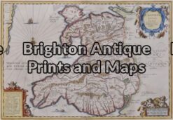
    Antique Map 4-165 – Wales Jansson – circa 1677 Hand coloured copperplate engraving 45cm X 35cm Condition A+

  • 4-168  England and Wales  c.1844
    SOLD
    Antique Maps

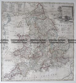
    Antique Map 4-168 England and Wales c.1844

Categories

  • Antique Maps
    • World
    • Australia & Pacific
    • Britain and Ireland
      • Britain
      • England
      • Wales
      • Scotland
      • Ireland
    • Europe
    • Asia
    • North America
    • South America
    • Africa
    • City Street Maps
    • Geological maps
    • Tallis
  • Antique Prints
  • Books & Gov't Reports
  • Manuscript Documents

© 2025 BRIGHTON ANTIQUE PRINTS AND MAPS. ALL RIGHTS RESERVED | Website by Blaze Online
Credit Card
Norton Safe Web Transaction
  • Home
  • Catalogue
    • Antique Maps
    • Antique Prints
    • Books & Gov’t Reports
    • Manuscript Documents
  • Recent Arrivals
  • About
  • FAQ
  • Register Interests
  • Contact Us
  • View Cart
  • Login
  • Currency
    WOOCS 2.1.5